Camino Mozárabe
This was to be our next Camino de
Santiago venture. We didn’t intend to walk all the way to Santiago but this is
a variation to the start of the Via de la Plata. This section runs from Granada
to Merida where it joins the main Via de la Plata route. It is 400 km long and
we reckon it will take about 3 weeks to cover the distance. The section of the
Via de la Plata we did previously from Sevilla to Merida is more popular with
plenty of albergue type accommodation. The route from Granada doesn’t have these
cheap hostels and we will have to use hotels, hostals and pensions.
Moira has spent the last month or
so researching the route through guide books, internet and blogs. She has
worked out an itinerary with reasonable distances between breaks and affordable
accommodation at each stop. There is only one section that will be tough; it is
38 km long with no possible ways to reduce it. It will be a case of starting
early and just keep going. We have gained experience with the amount we have to
carry when we did the Camino Norte last autumn. We have steadily managed to reduce
the weight of our packs over the years and now we only have about 6kg on our
backs and this doesn’t slow us down at all. I usually immediately change all
Moira’s plans for the trek as soon as we get started, this time I’ve promised
not to interfere.
The last few days we have been
packing up the ‘van in preparation of leaving. The arrangement is to leave the ‘van
here in the La Rosaleda storage area while we are away. Tonight, Sunday, we will
move to the storage spot and sleep there all ready for a quick getaway in the
morning. We will catch a bus to Sevilla and from there get a connection to
Granada. Moira had booked us into a hotel in central Granada near where we
found the yellow waymarker arrows for the Camino when we were there before
Christmas.

To the Start at Granada.
The
gale force winds of the last few days in Conil seemed even stronger
when we got up this morning. I had checked my diary for two years ago
when we left here for Sevilla to start the Via de la Plata and it was
gale force winds bending the trees then as well. I recorded that when we
reached Sevilla the wind had dropped considerable, hopefully it will be
the same today.
We
parked the 'van in the campsite storage area after breakfast and with
our rucksacks on our backs we set of on the half hour walk to the bus
stop. It was a struggle in the wind and the weight we are carrying
though relatively light will take getting used to. There was plenty of
time in hand before the bus arrived so had a coffee and a shelter in the
nearby cafe.
The
bus was on time and it took 2 hours to reach Sevilla. This was quicker
than last time as we only had one detour to pick up passengers in
Chiclana. Our connection to Granada was at mid-day at the other bus
station near the river and quite a walk away. We only had half an hour
to get there and didn't think even a taxi would make it in time. We
settled on the 4pm bus instead. We had researched all these times and
connections when we spent a day here a few weeks ago. One thing we
hadn't investigated was whether a bus ran from this terminus where we
had arrived at from Conil. Our luck was in and one left from here at
2:30pm which was much better and we didn't have to walk to the other bus
station. One other good thing was that the wind had dropped, just like
last time.
We
sat in the waiting room for the couple of hours until we left for
Granada. We had our books, the newspaper and a crossword on the iPad and
Kindle so we kept ourselves occupied. We had cold sausages that Moira
had fried earlier, some fruit and cool drink for lunch. The time passed
fairly quickly.
The
bus to Granada left on time and it took 3 hours to get there. It wasn't
a particularly exciting trip, all along the motorway but that made it
faster and there were no stops. As we approached the city the back drop
of the Sierra Nevada mountains were magnificent covered in a thick
blanket of snow.
The
bus station was well outside the city and although we had a copy of a
street map we couldn't find the bus station on it, so didn't know where
were on it. There was a sign outside pointing in the direction of the
Alhambra Palace which was near the centre so we took that direction. It
was a long walk but pleasant and warm in the sunshine despite the snow
on the mountains. We eventually found where we were on the map and
started to recognise places from our previous stay here last November.
We headed for the tourist information office that we knew was near the
Cathedral and got a better map of the city centre and directions to the
hotel Moira had booked us into. Hostal Veronica was only a short walk
away and our room small but big enough for us was en suite, it only cost
E30 for the night.
We
had got directions to the Convent de Santiago from the tourist office
and headed there first hoping to get our Camino credentials stamped. We
had checked out the Convent on our previous visit but it was all locked
up. The guide book said it only opened in the evening for peregrinos, it
was now 7:30m so we might be lucky . We weren't, it was still locked up
and we walked round the perimeter but no way to get in. On the way to
the Convent we passed a nice restaurant and had our dinner there on the
way back. We had the menu del dia and it was quite good. We both had
mixed salad to start then I had pork chops while Moira enjoyed some
fish.
It
was dark and getting cold as we made our way back to the hotel, we
should have worn something better than shorts. We had to settle for the
hotel stamp on our credentials to prove that we had started the Camino
here in Granada. In our room we got good WiFi and were able to listen to
some BBC Radio4 programmes before getting to sleep. Neither of us slept
very well; the pillow, a long bolster, was very uncomfortable and we
ended up chucking it out the bed and it was noisy outside. Not the best
start in preparing for a long walk.
March 11. 2014.
 From
the Ponte Genil it followed a road beside the river as it made its way
through the outskirts of the city. It crossed a busy street then under
the motorway to a walking cycling path through a wooded park. We met two
women walkers coming towards us and they spoke a little English. They
were delighted that we were walking the Camino and told us today's route
was very picturesque. The tarred track changed to a wide dirt track,
rough in places, that still stuck to the side of the river.
Unfortunately a snag arrived, the path was fenced off for some civil
engineering work being carried out. We crossed a bridge over the river
but there wasn't a path on the other side or any detour signs. We came
to a village which we thought was Atarfe, a place we should pass through
according to our guide book, but turned out to be Purchil well to the
south of where we should be, also the road that our trail was running
parallel to wasn't the N432 as on the map in our guide book. We walked
along the hard shoulder of this busy road in the direction of Sante Fe
which was the closest place on the map to Pinos Puente, our destination.
Luckily we came to a bridge over the river our route had been following
earlier and there was our track again at the end of the construction
works. In the blogs of people who had done this section they said that
the normal route was plagued with problems due to the construction of
the motorway and a high speed rail line. I assumed that this was a new
route designed to miss these obstacles.
From
the Ponte Genil it followed a road beside the river as it made its way
through the outskirts of the city. It crossed a busy street then under
the motorway to a walking cycling path through a wooded park. We met two
women walkers coming towards us and they spoke a little English. They
were delighted that we were walking the Camino and told us today's route
was very picturesque. The tarred track changed to a wide dirt track,
rough in places, that still stuck to the side of the river.
Unfortunately a snag arrived, the path was fenced off for some civil
engineering work being carried out. We crossed a bridge over the river
but there wasn't a path on the other side or any detour signs. We came
to a village which we thought was Atarfe, a place we should pass through
according to our guide book, but turned out to be Purchil well to the
south of where we should be, also the road that our trail was running
parallel to wasn't the N432 as on the map in our guide book. We walked
along the hard shoulder of this busy road in the direction of Sante Fe
which was the closest place on the map to Pinos Puente, our destination.
Luckily we came to a bridge over the river our route had been following
earlier and there was our track again at the end of the construction
works. In the blogs of people who had done this section they said that
the normal route was plagued with problems due to the construction of
the motorway and a high speed rail line. I assumed that this was a new
route designed to miss these obstacles.
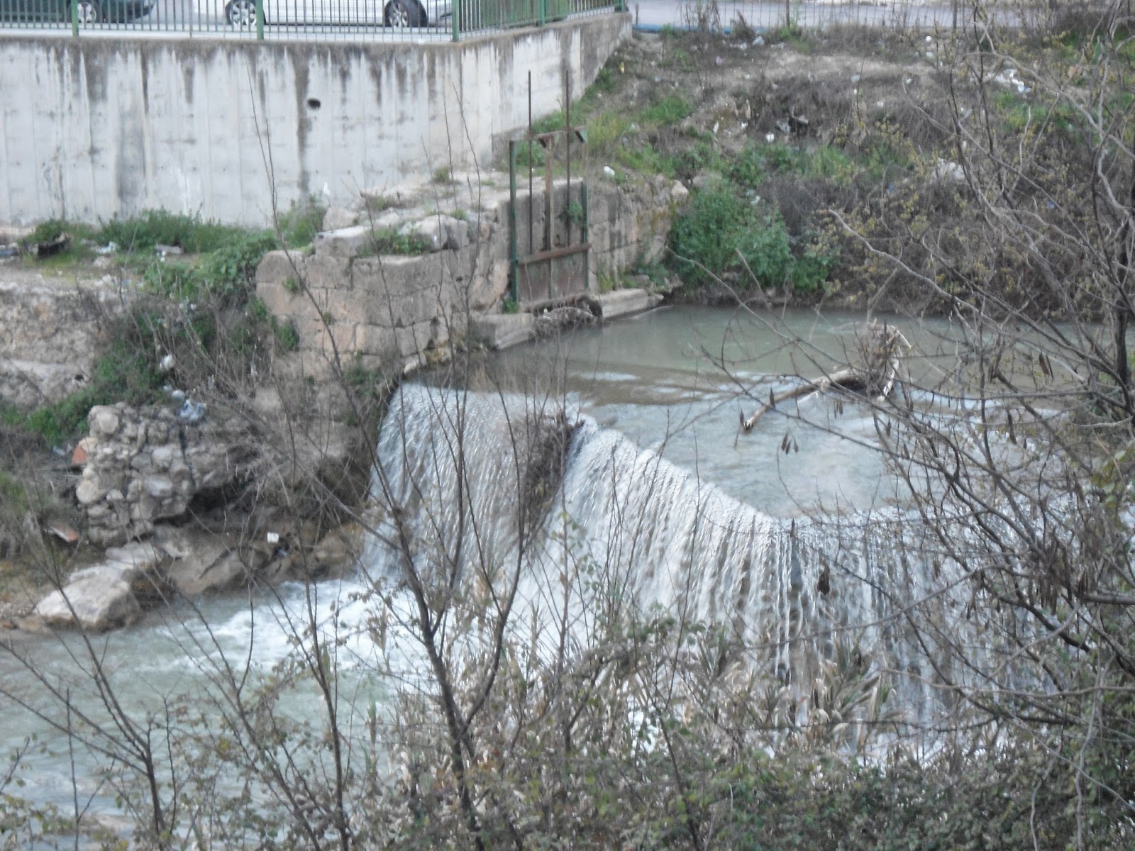
Back now with yellow arrows and shell markers to guide us we strode on confidently. It was very pleasant beside the fast flowing river with weirs and small waterfalls. The birds were whistling and chirping as the sun began to warm the place up and we were able to take off our fleeces.
We had a break and halved an apple between us, it was the only fruit we had left. As we sat we could quietly gaze behind us at the magnificent sight of the high Sierra Nevada mountains with the bright sunshine glistening from the snowy tops.
 The
track eventually turned away from the river and into the large village
of Pedro Ruiz by a narrow tarred road. I thought at first it was our
destination but were informed at the first bar we came to for a drink
that we still had a further 5 km to go. Moira remarked that if this
route becomes busy this would be the first 'watering hole' you come to
from leaving Granada. It could turn into a busy place. The final section
was well signposted with yellow arrows and shell markers all the way to
Pinos Puente which we could see tantalisingly in front of us. At the
bridge where the Camino crosses the river into the town centre, a
signpost indicated a Refugio de Peregrinos. This albergue was about 500
metres from this junction and behind large gates marked, Forestal. A
large guard dog came menacingly to bark loudly at us then went back to
attract Manuel who was in charge. The albergue was a huge barn like
structure among other buildings in the large grounds. There was a
curtained off dorm section with 8 beds and a separate area for dining
with a fridge and microwave. We filled in the register and had our
credentials stamped. This was all for a donation, Moira put in E20.
The
track eventually turned away from the river and into the large village
of Pedro Ruiz by a narrow tarred road. I thought at first it was our
destination but were informed at the first bar we came to for a drink
that we still had a further 5 km to go. Moira remarked that if this
route becomes busy this would be the first 'watering hole' you come to
from leaving Granada. It could turn into a busy place. The final section
was well signposted with yellow arrows and shell markers all the way to
Pinos Puente which we could see tantalisingly in front of us. At the
bridge where the Camino crosses the river into the town centre, a
signpost indicated a Refugio de Peregrinos. This albergue was about 500
metres from this junction and behind large gates marked, Forestal. A
large guard dog came menacingly to bark loudly at us then went back to
attract Manuel who was in charge. The albergue was a huge barn like
structure among other buildings in the large grounds. There was a
curtained off dorm section with 8 beds and a separate area for dining
with a fridge and microwave. We filled in the register and had our
credentials stamped. This was all for a donation, Moira put in E20.


Day 1: Granada to Pinos Puente. 18 km.
March 11. 2014.
When
I got up I had the camping gas cooker going for a cup of tea and we
listened to the news on the radio in bed while we drank it. For
breakfast we had muesli with milk Moira bought at a shop last night and a
croissant we had brought with us. We were packed up and on our way just
after 8am.
The
weather was nice as we made our way to the Ponte Genil through the busy
rush hour streets. The sky was clear and blue but it was bitter cold,
people wrapped up in heavy anoraks and scarfs looked at us in amazement
wearing shorts and a light fleece. When we were in Granada last November
we had traced the route by the yellow arrows from the Convento de
Santiago to the bridge over the Rio Genil. So we missed this part out
and headed directly to the Ponte Genil. We found the yellow route sign
at the bridge pointing to the road running along the side of the river.
Back now with yellow arrows and shell markers to guide us we strode on confidently. It was very pleasant beside the fast flowing river with weirs and small waterfalls. The birds were whistling and chirping as the sun began to warm the place up and we were able to take off our fleeces.
We had a break and halved an apple between us, it was the only fruit we had left. As we sat we could quietly gaze behind us at the magnificent sight of the high Sierra Nevada mountains with the bright sunshine glistening from the snowy tops.
The
track eventually turned away from the river and into the large village
of Pedro Ruiz by a narrow tarred road. I thought at first it was our
destination but were informed at the first bar we came to for a drink
that we still had a further 5 km to go. Moira remarked that if this
route becomes busy this would be the first 'watering hole' you come to
from leaving Granada. It could turn into a busy place. The final section
was well signposted with yellow arrows and shell markers all the way to
Pinos Puente which we could see tantalisingly in front of us. At the
bridge where the Camino crosses the river into the town centre, a
signpost indicated a Refugio de Peregrinos. This albergue was about 500
metres from this junction and behind large gates marked, Forestal. A
large guard dog came menacingly to bark loudly at us then went back to
attract Manuel who was in charge. The albergue was a huge barn like
structure among other buildings in the large grounds. There was a
curtained off dorm section with 8 beds and a separate area for dining
with a fridge and microwave. We filled in the register and had our
credentials stamped. This was all for a donation, Moira put in E20.
As
it was just after 2pm we reckoned that the bars and restaurants would
still be serving food so we dumped our bags in the dorm and headed for
town. Manuel had supplied us with a map and he marked the route to
follow through town to pick up the Camino in the morning. We used the
map now to check the roads and streets in preparation for tomorrow. It
was over the river by the bridge we had passed on the way up to the
albergue, and up Calle Real that was also signposted with yellow
way-marks. At the church the route was marked where Manuel had
highlighted on the map, turning to the right into Calle Ancha. We
carried on up C.Real, as this seemed to be the Main Street we were on,
but everything was closed presumably for siesta. We couldn't find a bar
or restaurant. We continued to where it joined the N342 hoping there
would be something on the main through road. There was; a busy little
restaurant with lots of cars outside and the clients were still eating.
We went in and had a huge meal from the menu del dia. We both had the
same, a big mixed salad, two huge pork chops with lots of chips and
mushrooms, finishing with iced cream and cream. There was also a bottle
of vino tinto, all for E19.
We
walked back along the N342 and found a Mercadona supermarket that was,
surprisingly, open. Moira bought bread, milk and some fruit for
tomorrow. We cut up through town to the bridge over the river then
'home' to the albergue. We were both tired after the first day's walk
and the enormous lunch so we lay down on the beds, I fell asleep while
Moira read from the Kindle. Later we showered, the water was piping hot
and we both felt livelier afterwards. We didn't feel like eating
anything our stomaches were bloated, we shouldn't have had so much for
lunch. Instead we lay on the beds reading until it was time to put out
the lights and get to sleep. There were dogs barking which disturbed us
initially but they soon quietened down and we both slept well.
March 12. 2014.
We
made our way down to the bridge and once over the river made our way up
C. Real. At the church It was a right turn onto C.Ancha. I had checked
our Cicerone guide last night and this was the way it also suggested. We
now followed the map that Manuel had marked, turned left at the mini
roundabout, straight past the football field, then by the cemetery to a
road junction. I thought he said that there was a roundabout there and
we turned right to a track to Moclin. Instead it was a tarred road,
similar to the route that some bloggers we are reading took. I
remembered that the guide book said the route went through olive groves
all the way to the first village of the day Los Olivares. I fished out
the guide book and it said to take the right fork at the mini roundabout
just out of town. We headed back and at that junction there was an
arrow pointing to the right. That was the way we headed but there was a
concern that it was no longer in use and that was why Manual and the
blog suggested the road. Our fears disappeared when we turned after a
short distance into the olive groves and all the direction indicators,
arrows, plaques and signposts, appeared to be brand new, and there were
plenty of them.

 Camino La Mozarabe Signs
The guide book said it was a wide gravel track and to ignore any left or right turnings just keep straight. We didn't have to worry all junctions were clearly marked and you couldn't go wrong. From the start of the track it was a steady uphill, quite steep in places through olive groves as far as the eye could see in all directions. This wasn't quite accurate as we could see very high mountains in the distance. They were all of Munro ( Scottish peaks over 900m/3000ft.) stature. Our final destination today was Moclin and it was perched in a col near the top of one of these monsters at 1300m, the height of Ben Nevis, Scotland's highest.
Soon
we stopped climbing and after some flat walking gradually began to
descend. We could see a village in front of us on the side of a hill
which I assumed to be Los Olivares. We came out of the olive groves and
met a tarred road, the arrow pointed up to this village. I was still
confident that it was the first village on our route but soon found it
was just a few cottages and called Bea Alte. We were going to stop and
make some coffee but decided to just have an apple and move on. The
markers sent us further up the hill from the village then suddenly
turned to the left, there was no mistaking the two big yellow arrows,
onto a contour path round the hill side. It was time to check the guide
book again. At the road before the village it said to turn left along
the road for 2km to Los Olivares, this contour path seemed to run
parallel with the road and must be a new route away from the traffic.
The olive trees had now changed to almond trees and they were in blossom, spring must be here. Soon we could see Los Olivares ahead down in a valley, a much bigger place than the village I mistook for it. Behind was a large mountain and we could see the houses of Moclin in a col near the top with castle ramparts and a wall high above it. A number of paths cross-crossed the mountain side and we could make out the route we would have to climb later, on our way to the top.
The
blog we had been reading said to call at the Bar Calefato opposite the
town buildings and they arrange accomodation at the Casa Rural Briza. We
found the bar but the woman seemed clueless, fortunately a customer
knew what we wanted and arrange a room for us. It was a bit expensive,
E50, but it was quite luxury for us and it had a kitchen so we could
cook our dinner and save some money; we wouldn't eat so much as well. It
had become quite cold, probably the altitude we were at, so Moira got
all the heaters going to warm the place up. We had a cup of coffee
before showering, the water was piping hot.
Day 2: Pinos Puente to Moclin 14km.
March 12. 2014.
We
were both awake at 6am and I made a cup of tea. We stayed in bed for an
hour drinking our tea, with Moira reading while I worked on my blog.
This morning we had a banana with our muesli, with bread and jam to
follow. We got away at just after 8am. The big German shepherd that
seemed to have got used to us yesterday afternoon and allowed us to pat
it was now in a bad mood again, he would have attacked as we passed if
he hadn't been chained up. It was a bit cloudy this morning with a cold
wind blowing. We both wore our leggings under our shorts to keep our
legs warm. Midway through the morning it warmed up as the clouds cleared
and the sun got through then we were able to take them off.
 |
| The gate to the albergue |
Camino La Mozarabe SignsThe guide book said it was a wide gravel track and to ignore any left or right turnings just keep straight. We didn't have to worry all junctions were clearly marked and you couldn't go wrong. From the start of the track it was a steady uphill, quite steep in places through olive groves as far as the eye could see in all directions. This wasn't quite accurate as we could see very high mountains in the distance. They were all of Munro ( Scottish peaks over 900m/3000ft.) stature. Our final destination today was Moclin and it was perched in a col near the top of one of these monsters at 1300m, the height of Ben Nevis, Scotland's highest.
 |
| Olive Groves and more Olive Groves |
 |
| Distant mountains to climb. Munros? |
 |
| It's now almond trees. |
The olive trees had now changed to almond trees and they were in blossom, spring must be here. Soon we could see Los Olivares ahead down in a valley, a much bigger place than the village I mistook for it. Behind was a large mountain and we could see the houses of Moclin in a col near the top with castle ramparts and a wall high above it. A number of paths cross-crossed the mountain side and we could make out the route we would have to climb later, on our way to the top.
As
we dropped steeply down to the town we came to an old communal laundry.
It was a number of washing sinks with mountain water running through
them. It was walled and sheltered from the cold wind so we took
advantage for a break and I made some coffee. Moira decided it was lunch
time and made bread and cheese to go with the coffee. On our way again
it was still a long drop before we crossed a river and began to climb.
Shortly
after the start of the ascent the guide book said to keep to the right
of the huge rock that was in front of us. At a junction of tracks there
were lots of signs, for the Camino and a local hiking route that said to
go left of the big rock, and a signpost pointing left said 'Moclin
2.7km'. To its right was a narrow mountain track and this may have been a
shorter steeper climb to the top, the guide book indicated 2km, but we
kept to the 'official' maybe new route. It was a winding zig-zag gravel
track all the way to the top. It was very steep in places; after
dropping down to the river and immediately climbing it reminded us of
some of the trails in Napal and the Himalayas.
We stopped at the Ermita de San Anton, a religious shrine, for a rest and to admire the views of the magnificent mountains that surrounded us. In the distance we we could make out the rounded tops of the hills behind Pinos Puente and the olive groves we had walked through this morning. It was still a climb to the top and we passed the point where the track going round to the right of the big rock joined onto the gravel track. Soon houses began to appear but it was still a climb to the plaza in the centre of Moclin.
 |
| River crossing at La Olivares |
 |
| Ermita de San Anton |
We stopped at the Ermita de San Anton, a religious shrine, for a rest and to admire the views of the magnificent mountains that surrounded us. In the distance we we could make out the rounded tops of the hills behind Pinos Puente and the olive groves we had walked through this morning. It was still a climb to the top and we passed the point where the track going round to the right of the big rock joined onto the gravel track. Soon houses began to appear but it was still a climb to the plaza in the centre of Moclin.
 |
| Moclin on the hilltop |
 |
| The Castle above the streets of Moclin. |
Moclin
was an important town in the 14th and 15th centuries. The castle above
the town was no doubt a fortress guarding the pass through the mountains
to Granada. On two high adjoining peaks we could see watch towers to
give warning of any approaching armies. It was still a stiff climb up to
the castle and we had enough for one day, also it was quite cold
outside.
There
was a small supermarket in the square but Moira had to wait until
6:30pm for it to open and stock up with something for dinner. We had a
pasta with stewing steak and tomato purée. It was very nice with the
bottle of red wine to go with it. After getting the washing up done we
read for a while then got to bed, it was warmer there and more
comfortable. Moira continued reading but I was very tired and soon
dropped off. The beds were very comfortable and we both slept very well.
When we reached the N342 the road signpost said Alcala de Real 17km, meaning we had covered 8 km in 90 minutes, a bit unlikely. We were on the busy road for only a short distance before we were directed by a yellow arrow to another gravel track. This was quite broad and smooth initially but then changed to a rough farm track through olive groves. At this point there were about four or five brightly painted yellow arrows on posts and rocks. The track began to climb steadily but no more waymarks, we thought they might have run out of paint with all the previous arrows. At the top of the hill at last a solitary arrow pointed straight ahead but it was on the dried tracks of a tractor as it had gone through mud. Eventually the track disappeared and there were no signs of 'yellow' anywhere. I checked the Cicerone guide while Moira looked up the blog on the iPad. The Cicerone was useless, I think it had gone a different way but the blog helped. They had run into the same problem at the exact same spot and had scrambled up the side of the hill to the right where they reached a path and found arrows. We did the same going to the right and heading for a white building we could see on the ridge above. It was a tough scramble but eventually we reached an obvious track and followed it to the building on the ridge. At this big white barn it joined a gravel road and with a sigh of relief there was a yellow pointer directing us to the right. Somewhere we must have missed a turning or the waymark on the stone at the top of the hill could have been moved, maybe when the farmer was ploughing.
The
gravel track now wound its way down into a long valley with outstanding
views of the surrounding hills and the green olive groves that ran down
the length of the valley. We found a sheltered spot near a power
mini-sub station where there was a place to sit and brew up some coffee.
After our break the track led us to the N432 again. The distance figure
displayed now said 11 km to Alcala de Real. We had covered a 6 km
'equivalent' in 90 minutes this time but with a coffee break and getting
lost. We had about 1.5 km on the highway before we were directed onto a
gravel track that went up a steep climb to the little town of Ermita
Nueva. We carried on through the nice colourful houses and came across a
shop with a sign ' information de peregrinos'. It turned out to be a
cheese factory shop; the woman didn't know anything about the Camino but
did stamp our credentials and gave us a free tasting of her cheese. The
town was widely spread out and eventually we cleared the houses and
onto a gravel track again which led us to the N432, now only 5 km to go
according to the road distance sign.
Day 3: Moclin to Alcala la Real. 25 km.

March 13. 2014.
I
was awake early, at 5:30 am but waited for another half hour before
getting up and making tea. We lay in bed until 7 am reading and drinking
tea before getting up for breakfast. We were packed up and on the go at
8 am this morning. It was another good looking day with a cloudless
blue sky, there was no wind so it didn't feel as cold as yesterday but
we both had our leggings on again.
The
route was well marked as we climb further up through the town
eventually reaching the top of the hill where we had magnificent views
of the castle above us and a tremendous panorama of the mountains in
front of us. It was a steep downhill on a track of loose gravel and
where we had to be careful not to slip. It didn't go down as far as we
came up yesterday and soon it was fairly level as we reached the
fountain, Fuente del Malalmuerzo. Here the guide book said to stay on
the road keeping right but the waymarks pointed to a gravel track to the
left, that was the way we went. This route avoided the Cordel de las
Gallinas noted in the guide book but took us to a tarred road where we
turned left and met the N342 a few kilometres later.
 |
| Alojaminto Rural La Lola |
 |
| Rolling countryside descending from Moclin |
 |
| One of the many watchtowers on hills |
When we reached the N342 the road signpost said Alcala de Real 17km, meaning we had covered 8 km in 90 minutes, a bit unlikely. We were on the busy road for only a short distance before we were directed by a yellow arrow to another gravel track. This was quite broad and smooth initially but then changed to a rough farm track through olive groves. At this point there were about four or five brightly painted yellow arrows on posts and rocks. The track began to climb steadily but no more waymarks, we thought they might have run out of paint with all the previous arrows. At the top of the hill at last a solitary arrow pointed straight ahead but it was on the dried tracks of a tractor as it had gone through mud. Eventually the track disappeared and there were no signs of 'yellow' anywhere. I checked the Cicerone guide while Moira looked up the blog on the iPad. The Cicerone was useless, I think it had gone a different way but the blog helped. They had run into the same problem at the exact same spot and had scrambled up the side of the hill to the right where they reached a path and found arrows. We did the same going to the right and heading for a white building we could see on the ridge above. It was a tough scramble but eventually we reached an obvious track and followed it to the building on the ridge. At this big white barn it joined a gravel road and with a sigh of relief there was a yellow pointer directing us to the right. Somewhere we must have missed a turning or the waymark on the stone at the top of the hill could have been moved, maybe when the farmer was ploughing.
 |
| One of the communal laundries |
The
guide book said that we should walk along the busy road for a short
distance then take a track running from the other side into the
countryside. We didn't see any track or way-marking directing us to one;
later when we checked the blog they couldn't find it either and like
them we ended up walking all the way to Alcala de Real on the hard
shoulder of the highway. There was a cafe/bar a few kilometres on but it
was closed, we sat in their carpark and had lunch anyway. I made coffee
and Moira spread cheese on some rolls she bought last night. After that
it was a just 3 km to our final destination.
We
picked up yellow arrows again when we made our way along the main
street, Avenida de Andalucia. We stopped at a 3 star hotel, Torrepalma,
but they wanted E60 for a room. Further along, as we came into the old
town, we tried the Hostal Rio de Oro but they were full but the woman
directed us to Hospederia Zacatin where we got a room. This was where
the people who wrote the blog we were following stayed but we paid E5
less, E40 for a nice en suite room.
After
relaxing stretched out on the bed for an hour we had a shower then went
for a wander around the town. There was a tourist info office close by
where we got a town map and also other maps of the Camino route through
various towns, always the difficult part, that we come to in the next
few days. The guy was very helpful and spoke excellent English. This was
another town with a Castle on the hill above. We walked up the hill to
the walls and walked round the outside, the Castle closed for visitors
at 5 pm, we were just too late. From the surrounds of the Castle we got a
wonderful view of the countryside and were surprised at the size of the
town stretched below. The houses seemed all cramped together with
narrow lanes in a maze connecting the streets. On the way down we
followed signs to the Eglise de San Juan. It was an old 15th century
church but unfortunately it was also closed. As it was beginning to cool
down now we headed back to the hotel, on the way we found a supermarket
now open with the end of siesta where we got bread, milk and fruit;
also a couple of beers.
 |
| The Castle above Alcala la Real |
Back
at the hotel we sat and read while drinking our beers and eating
peanuts until the restaurant downstairs open for dinner. We went down at
8pm the usual time for the Spanish to start eating. The tables in the
restaurant were all set ready for meals but there was nobody else there.
We sat down and eventually a waiter appeared and started rabbiting away
to us in Spanish. He either said that they didn't serve until 8:30pm or
that they were closed for the night. We went out to find somewhere
else, it was bitterly cold now and we were attracting attention in our
shorts. This was the first town in Spain where the main street wasn't lined with bars and restaurants. At last we spotted a
cafe/ bar in a park area opposite. We just looked in the door and a
waiter appeared and ushered us to a table with the menu; this was how a
business should be run. We just ordered one plate each and shared; fried
chicken breasts and a mixed salad. When he brought us glasses of wine
he also put on the table fried meat between bread and a few potato
crisps, we thought this was the chicken but it was just tapas to keep us
going. As usual the dishes when they arrived were huge and the one
plate each sharing was more than enough. When we got back to he hotel I
checked the dining room, it was still empty; I don't know how these
places expect to survive if they turn away paying customers.
In
our room we went straight to bed and read for an hour before getting to
sleep. The room was nicely warm and I slept on top of the covers in my
sleeping bag, I find it more comfortable. It was a bit noisy at first
with people outside in the street and there is always somebody in hotels
moving the furniture about at odd hours but eventually it all quietened
down and we slept well.
Day 5: Alcaudete to Baena. 27 km.
March 15 2014.
It wasn't long before we were in trouble again by going the wrong way. Fortunately a farmer working on his olive trees redirected us. The track now wound its way round the hillsides and through yet more olive groves to meet up with the N432. The highway took us over the Rio Guadamoz then we were out into the olive groves again and on gravel tracks. We found a pool with a wall round it where we could sit and have a cup of coffee and a break. The distance signs on the N432 showed that we had only covered 8km in the 2.5 hours we had been going due to our getting lost. We thought when we started off again we had still plenty of time if we didn't get lost again but immediately came to a halt when we couldn't find markers at the first junction in the tracks. After a lot of searching I discovered a cross, 'not this way', on one fork; so we got going again. Not for long, there were more difficulties as we entered olive groves that had been ploughed up and the waymarks had disappeared. Eventually we entered a Nature Reserve and a lake where we picked up markers again. Later I discovered that his was the Cicerone route but had ignored the guide as the map showed it running very close to the highway which we certainly weren't doing.
At
the lake, Laguna de Salobral, the arrows initially guided us round the
right of the lakeside but then disappeared. We followed the path near
the eage of the water but found later that we should have headed up to
an old railway line, originally used for the transportation olive oil,
and had been converted into a cycle track. We did eventually meet up
with it at the original railway halt/station. This seemed to be a
picnicking and recreational area with lots of cyclists about. The lake
is only about a metre deep and unlike now is dried up for much of the
time. As we reached the road a sign pointed us again onto a gravel track
to the right. We were reluctant to wander in more olive groves and
found someone who spoke English. He said if we kept on the road until we
crossed a bridge then turned first left we would reach the N432. That
was now our plan.
When
we reached the junction Moira went on further to check that it was the
correct turning and round a bend discovered yellow arrows. The cross
country track we avoided came to the road at that point and the way
indicated was straight along the road. This didn't last long and it was
into the country again a short time later. This time it wasn't so
tricky, the track was wide and obvious even though the waywarkers were
few and far between. At 1:30pm it was our lunch stop and we had bread
and cheese, an apple and a cup of coffee plus a well needed rest. In
half an hour we were on the go again and I estimated that we had 10 km
to go, another 2 hours at least. We were now making good time on a nice
flat track through these endless olive trees and it came as a complete
surprise after an hour when we saw Baena stretched along a ridge on the
other side of a small valley. There were now plenty of signs and arrows
when we didn't need them as we climbed the steep road up into the town.
Day 4: Alcala la Real to Alcaudete. 24 km.
March 14 2014.
We were both awake at 6am and made a cup of tea on the camping stove. We read for an hour in bed before getting up for breakfast. Looking out the window it promised to be another nice day but probably cold to start so on went the leggings again. We were all packed and ready for the off at 8am.
We were both awake at 6am and made a cup of tea on the camping stove. We read for an hour in bed before getting up for breakfast. Looking out the window it promised to be another nice day but probably cold to start so on went the leggings again. We were all packed and ready for the off at 8am.
Reading
the Cicerone guide I was under the impression that it would be a
complicated business getting out of the town. They gave two alternative
routes which seemed to involve many twists and turns while we followed
the lines the man at the tourist info marked on the street map for us. This involved going up the main street
to where we turned up to the Castle last night but instead carried on
down the hill to a roundabout where we took the street named Calle Nuevo
and from there it was straight. The tarred road changed to gravel and
we could see it continue through the olive groves away into the
distance.
 |
| Fortaleza de la Mota |
Looking
back we had a magnificent view of the Castle, Fortaleza de la Mota, on
top of the hill silhouetted against the early morning sunshine. This
was not only an Arab fortress but originally the town itself up until
the 19th century. The complex also includes the hilltop abbey, Iglesia
Mayor Abatial and displays in the architecture and carvings innumerable
examples of the scallop shell symbols of St. James.
Today's
walk was through endless olive groves. The lines of olive trees
stretched in lines in all directions and up the hillsides nearly to the
tops. Workers were busy in many places pruning and the sounds of their
chain saws could be heard for miles. With the number of trees to
maintain this must be a never ending job. Alcala la Real seemed to be a
centre for olive oil production as we passed a couple of factories, in
an industrial area coming into the town, that were concerned with the
pressing and extraction of the oil. At our meal last night the olive oil
on the table was a variety locally produced.
Today's
route was fairly straight forward and the waymarked course followed
closely to that of Cicerone and the N432 highway. The only problem we
encountered was the crossing of the N432 where it split with the N432A
to Castillo de Locubin. The gravel path came down to the road side just
before the split but there was no sign of where to cross or any obvious
safe way over. The path then climbed up the hillside away from the
highway and we could see on the other side of the road the path we
should have been on. Our track now wound its way up the hill further and
further away from the N432 and the tunnel under the highway at the
split junction could be clearly seen. Cicerone, the blog we are
following and now ourselves ended up scrambling down the muddy hillside
to go through the tunnel and pick up a track at the other end that went
up to join the waymarked route.
 |
| Spring flowers starting to appear |
It
was another nice wide track and it cut through between the hills to
meet up with N432 again just before the village of Ventas de Carrizal.
On the track before the highway we found an old abandoned cupboard which
made a good seat to have a cup of coffee that I quickly brewed. There
were Magdalena cookies to go with our drink that Moira bought last
night, the first since our last Camino; they're light to carry. When we
reached the N432 there was a shell marker on the barrier on the other
side of the road, meaning we were to climb over the barrier to a track.
This was where we went wrong yesterday and ended up walking along the
hard shoulder to Alcala; there had been a similar marker on the barrier
opposite when came to highway but we mistook its meaning.
Ventas
de Carrizal seemed to be just houses and a few small farms set among
the olive groves. There weren't any shops as far as we could see never
mind a bar or an hotel. The only other point where we had worries was on
leaving this village. When across the bridge over the fast flowing
river at the exit from the village we arrived at cross roads. The yellow
arrow was not very distinct but seemed indicated a turn to the left,
the track ran beside the river and parallel with the N432 in the
distance. We were a bit worried as the next waymark was a long time in
coming and were nearly at the point of turning back and checking again
at the cross roads. After that it was more or less a straight gradually
climbing track into the hills through more and more never ending
parallel lines of olive trees. It was 10 km to our destination and even
though it was nearly all uphill we set a good pace and covered the
distance in 2 hours.
 |
| Tiled walkway into Alcaudete |
Coming
round the side of a large hill we met a tarred road with houses and
below in the valley was the large town of Alcaudete. This was another
fortress town and the Castle dominated above the houses. The route
seemed to be heading straight down into the town centre when we were
directed to the left at the Santuario de Nuestra Señora de la Fuen Santa
a very large church with lovely gardens and benches. We thought it was a
detour to visit the church but the route turned right along a
delightful wide tiled tree lined walkway through a public park. The
street we arrived on was Avenida Andalucia and this was the one the
hotel, Hostal Spa Rueda,we were looking for was on. We soon found it and
got a nice double room. After dumping our bags we went to the
restaurant for a late lunch; we can't be bothered with this late night
dining that is the Spanish custom. We had the menu del dia which again
was more than we needed but we ate anyway. This meant dozing on our beds
for the rest of the day and reading.
I
didn't go out again it was too cold but Moira went to the supermarket
for bread and milk; she also got a couple of beers for later. We stayed
in the room and didn't bother with anything else to eat, lunch had been
plenty. It was just a cup of coffee and a beer while watching tennis on
TV.
 |
| Castle above Alcaudete |
Day 5: Alcaudete to Baena. 27 km.
March 15 2014.
I
was awake at 6am again, tea in bed and reading until 7am, breakfast and
pack, we were on the road an hour later. The weather was very nice and
although we were rigged out in our leggings it promised to be a very hot
day. It did turn hot and the leggings were soon off and fleeces
followed not long after.
 |
| Add caption |
 |
| View of Castle on leaving Alcaudete |
Getting
through the town and out on the route turned out to be fairly straight
forward though when the author of the Cicerone guide did it they were
building new roads and motorways so the route then was disrupted and
confused. According to the map in the Cicerone guide the route should
follow the N432 fairly closely but the waymarks as we left Alcaudete on a
gravel road took us away for the highway. We seemed to be progressing
well and chatting away not paying attention that we missed an arrow. We
ended up a couple of kilometres the wrong way; fortunately the road led
to a house so we knew right then that we had gone wrong. We retraced our
steps and found an arrow at a junction hidden behind a clump of tall
grasses; we were on track again but had lost 45 minutes. The point where
we had missed the turning was at an enormous conglomeration of solar
panels. They were in units of 48 panels, each single panel similar in
size to the ones we have on our house. There were literally hundreds of
these 48 panel baks here. That also helped to distract us from the
change of direction arrow.
 |
| Solar panel 'farm' |
It wasn't long before we were in trouble again by going the wrong way. Fortunately a farmer working on his olive trees redirected us. The track now wound its way round the hillsides and through yet more olive groves to meet up with the N432. The highway took us over the Rio Guadamoz then we were out into the olive groves again and on gravel tracks. We found a pool with a wall round it where we could sit and have a cup of coffee and a break. The distance signs on the N432 showed that we had only covered 8km in the 2.5 hours we had been going due to our getting lost. We thought when we started off again we had still plenty of time if we didn't get lost again but immediately came to a halt when we couldn't find markers at the first junction in the tracks. After a lot of searching I discovered a cross, 'not this way', on one fork; so we got going again. Not for long, there were more difficulties as we entered olive groves that had been ploughed up and the waymarks had disappeared. Eventually we entered a Nature Reserve and a lake where we picked up markers again. Later I discovered that his was the Cicerone route but had ignored the guide as the map showed it running very close to the highway which we certainly weren't doing.
 |
| Laguna de Salobral |
 |
| Track through olive groves to Baena |
We
asked directions and soon found Hostal Rincon, an inexpensive hotel,
according to Cicerone,in the town square. We got a room and showered
before going down for a beer and to settle the bill. It wasn't cheap as
the guide book lead us to believe, E50. To keep in budget Moira went out
later to find a supermarket and managed to get a barbecued chicken and
some salad which we ate in our room with a nice red wine. It was
starting to get cold in the evening and the heater/air con either blew
out very hot or freezing cold air. Moira ended up turning it off when
the room got too hot and on again when it cooled. There was WiFi and we
were able to listen to the BBC radio on the Internet.
March 16 2014
The
final section was the normal for a Camino, you can see the town but it
doesn't seem to get any nearer. But eventually we were there and it was
now the problem of finding the albergue. The church had a big steeple
and was on a hill so we made for that. We asked people for directions to
the albergue but they pointed away from the church; finally we realised
they were directing us to the police station. The policeman,when we got
there, was very helpful and friendly; he gave me the key to the
albergue, stamped our cards, photocopied our passports and marked the
location of the hostel on a street map. We headed back to the church and
soon found the door that the key fitted. It was a large house with two
small dorms upstairs with a total of 6 double bunks. Nobody else was
there we had it all to ourselves. I was going to have a cold shower to
freshen up but found that there was actually plenty of boiling hot
water. After we had both showered and changed we made our way into the
town to find a restaurant.
Day 6: Baena to Castro del Rio. 20km.
 |
| We used the albergue instead |
We
are getting into a regular routine now; up at 6am make the tea, relax
and read for an hour, breakfast, pack and out at 8am. It was another
fine day and it got hot very quickly, we had only been walking for 45
minutes when we stopped and got out of our leggings and fleeces. It was
really glorious, the sky was bright blue and not a breath of wind.
The waymarking was
a complete contrast to yesterday, there were more than enough arrows
and the direction to take at all junctions was properly indicated. It
was a straight road out of town and once we went under the N432 it was
onto a gravel track through more and more olive groves. This track ran
in the same direction as the highway but it was some distance away. The
route was an undulating but the rises and falls weren't too steep and we
made excellent time. Eventually we met a minor road which we followed
to a bridge over the Rio Guadajoz. This was the same river that we
crossed yesterday morning but now there was much less water in it. This
was a new bridge, the old one was still beside it unused and we took
advantage of a wall on it to sit and have our morning coffee.
When
we started off again it was on a very minor tarred road all the way to
Castro del Rio, just 10 km away. It ran beside the river which was now
in places no more than a large puddle of water. Along side the river
there were various kinds of trees and shrubs making a change from
olives. This road had very little traffic and was a favourite venue for
joggers and cyclists. We continued the fast pace of earlier and would
have reached our destination by 12:30 pm if we hadn't stopped to talk to
a couple from Belgium going the other way, from Cordoba to Granada.
They had spent last night in Castro del Rio and told us about the
albergue there. It was next to the church high on the hill and the key
was obtained from the police station nearby. It was a donation and the
only thing wrong they said was that the water in the shower was cold.
 |
| Cathedral tower |
 |
| The Cathedral from the town square |
In
the town square there were lots of tables and chairs set out and lots
of people dining. The chairs etc were of different colours and grouped
together, different bars around the square looked after each section. We
sat down at the first group of tables and ordered one plate each from
the al a carte menu, we didn't know what we were getting. We had a glass
of wine right away and that came with some tapas, Mexican tortilla. We
shared the two plates, one was a fish dish and the other fried pork.
When we ordered another round of drinks they came with more tapas, this
time grilled ham and cheese on bread.. It was a good meal and not too
much but again we both felt tired after our walk together with a larger
mid-day meal than we are used to.
We
had a walk around the perimeter of the old town. The church was closed
but the outside was impressive with a tall square bell tower and a
stork's nest on top; the stork hasn't arrived yet from sunnier climes.
This was another fortress town but there isn't much left of the castle,
just two large square towers and one wall which were all crumbling. We
headed round the narrow streets and
lanes until we had completed a full circle and were back at the
albergue. I had a lie down and slept for half a hour then worked on the
crossword in yesterday's newspaper which Moira downloaded last night.
For
'dinner' we had an apple and a cup of coffee brewed on the Gaz stove.
The lighting was much better in the albergue, strip lighting not the
modern energy efficient bulbs, so we were able to until much later
before getting to sleep. The church bells chimed the hours and was a bit
disturbing but we managed a good night's sleep anyway.
We
were on the road for a short distance before cutting onto a gravel
track through olive groves. But at last it wan't all olive groves, now
there were fields of wheat and a couple where, Moira said, the pants
were beans. There were some long steep hills and the Dutch couple who
had pulled away from us on the flat were slowed down on the ascents,
they don't have a lot of hills in Holland for training. Soon there came
into view the white buildings of houses going up a pointed hill with a
castle sitting on top. This shouldn't be on the route we were expecting
to take and correctly assumed it was the town of Espejo and we were on
the southern route to Santa Cruz. It didn't make much difference as the
distance was the same in both directions. It looked like a good place
for a visit anyway, and the waymarks were excellent on this route, so
far.
As
we entered the town our Dutch companions had got ahead of us and we let
them go when we spotted some benches beside a fountain. We stopped for a
break and I made a cup of tea. I used the water from the fountain and
the tea tasted much better than with the water at the hotels which had a
chlorine flavour. When we got going again the route markers led us up
the steep hill that climbed to the castle at the top. Half way up it
levelled out at the piazza in the centre of the town, a large square
lined on two side with orange trees. There we met the Dutch couple again
they were coming from a bar where they stopped for coffee. We walked
the rest of the way with them.
still some of the
barbecued chicken left from the other night and Moira made a mushroom
sauce from a packet of soup she had and cooked it with pasta, it was
very nice.
We spent the evening reading and listening to the radio. Although we were on the N432 the traffic noise wasn't bad but the hotel walls were thin and the person in the next room could be heard quite clearly talking on his phone. It was quiet later and we had a good night's sleep again.
Day 7: Castro del Rio to Santa Cruz. 22 km.

March 17 2014.
I slept a bit late this morning not waking until 6:40pm. I got up and made tea but didn't go back to bed but prepared the rest of the breakfast. Once dressed and packed first we headed down to the police station to return the albergue key. When that was done we went to the square where we dined yesterday, to find the route, Cicerone gave instructions from there.
I slept a bit late this morning not waking until 6:40pm. I got up and made tea but didn't go back to bed but prepared the rest of the breakfast. Once dressed and packed first we headed down to the police station to return the albergue key. When that was done we went to the square where we dined yesterday, to find the route, Cicerone gave instructions from there.
The
route to Cordoba is 37 km and a bit too far for us but there was loop
to the town of Santa Cruz where we could spend the night. It was about
half way but the loop added on approximately 8 km to the section. At the
church Madre de Dios we took the left fork as instructed and should
have continued down a long street but only a short distance down the
hill a Camino sign pointed down a narrow lane to the left. We decided to
ignore the guide book and follow the waymark. This lane ended at the
river but no more route signs could be seen, we asked a walker out
exercising and she said to cross the bridge over the now familiar Rio
Guadajoz. Our book made no mention of crossing the river and we were
standing around scratching our heads when a couple of peregrinos
appeared. They were from Holland and they told us the route was, in
fact, over the bridge. We tagged along with them and soon yellow arrows
and shell signs began appearing on rocks and posts. It appeared to be
the route all right but different from the one described in Cicerone.
 |
| Espejo on the hill top |
|
| Town centre of Espejo with row of orange trees |
The
markers now had us continuing to climb until we were at the castle
walls and there they stopped. We walked round the perimeter of the
castle but found nothing to direct us. We asked people for the Camino de
Santiago but only got blank stares. We tried Santa Cruz with better
results and were directed to a track we could see far below and heading
towards a white blur in the distance that we assumed were the houses at
our destination. We made our way down through the narrow streets and
lanes to reach what we thought was the track we saw from above. There
were still no waymarks but a car coming along the track assured us that
it was the way to Santa Cruz. We all headed that way. The N432 could be
seen a short distance away running in the same direction, I checked the
map in the Cicerone and this was as it should be, it was only the lack
of yellow arrows that was the worry.
Once
we dropped down from the hill it was nice smooth flat track and the
olives were now getting less and less as more grain crops were in
evidence. We were making good time and striding out when the track
suddenly bent to the right and going in the wrong direction. The
continuation going straight ahead was just tractor tracks crossing the
fields. We all headed up a nearby hill to survey the surrounding
countryside and assess our position. The town of Santa Cruz could be
clearly seen in the distance but no track that was obviously heading
that way. The tractor tracks crossing the field were going towards the
N432 and we knew that Santa Cruz was on the highway so we set out on the
tractor tracks. We reckoned that if we didn't find a marked track we
could walk along the N432 hard shoulder.
It
was rough going on our feet walking on the tractor treads in dried mud
but it wasn't far to the highway which we ended up having to walk along.
It wasn't far before we got a view of the town but as usual it didn't
seem to get nearer. After 3 km we picked up yellow arrows and after
crossing the Rio Guadajoz, yet again, we picked up a path into the town.
Our Dutch friends went looking for a place to eat while our priority
was a bed for the night. There was a hotel, that the bloggers we follow
used, on the N432 which passed through the centre of Santa Cruz. It was
called Casa Jose and we were pleasantly surprised at the price E35, the
room was very nice.
After
we dumped our bags it was down to the bar for a cool pint of beer. They
also supplied a big bowl of olives to go with our drinks. When we got
back to the room we had lunch, cheese on bread and a cup of tea. After
showering Moira found that there was WiFi and didn't require a pass
word. We checked the email, nothing important, then I tuned into the BBC
radio and had some entertainment and news. There was
 |
| Casa Jose |
We spent the evening reading and listening to the radio. Although we were on the N432 the traffic noise wasn't bad but the hotel walls were thin and the person in the next room could be heard quite clearly talking on his phone. It was quiet later and we had a good night's sleep again.
Day 8: Santa Cruz to Cordoba. 24 km.
March 18 2014
While having our breakfast this morning Moira checked out accommodation in Cordoba on the Web. She used the booking site, Booking.com, where we got the hotel in Granada and she was successful again. The Cordoba hotel, Hostal Alcazar, was only a few minutes walk from the Cathedral and was costing only E64 for two nights; we were having a sightseeing rest day in Cordoba.
While having our breakfast this morning Moira checked out accommodation in Cordoba on the Web. She used the booking site, Booking.com, where we got the hotel in Granada and she was successful again. The Cordoba hotel, Hostal Alcazar, was only a few minutes walk from the Cathedral and was costing only E64 for two nights; we were having a sightseeing rest day in Cordoba.
It
was another beautiful day, no leggings on as it was nice and warm, and
it wasn't long before our fleeces were also off. It was the normal
routine before we left and
surprisingly the bar was quite lively as we passed through it to go out.
Before leaving the town we went to a bakery that Moira discovered
yesterday when shopping and bought some bread. There had been one arrow
as we came into town and we followed that direction and were now
becoming slightly doubtful about leaving before seeing another one. We
were approaching the outskirts and ready to try asking a man coming the
other way if we were on track when at last a confirming waymark
appeared. We now strode confidently forward knowing it was a straight
road to where it joined the main route from Castro del Rio to Cordoba.
After
an initial climb it was fairly flat giving us some good easy walking to
loosen up. There were lots of large farms and the crops were a mixture
of grain and olives. The traffic was light and we didn't see the Dutch
couple from yesterday they may have carried on but it is a long walk to
Cordoba from Castro del Rio via Santa Cruz. We did meet a man coming the
other way, out exercising his greyhounds. He stopped to talk to us and
explained the route we should take, in fast Spanish. Here are two
questions; why is it when we are lost nobody appears to know the Camino
de Santiago route or even where the next town is, but when you are
confidently on track there is somebody that wants to confirm it or tell
you a better way, and secondly the English know that if you speak loudly
to an ignorant foreigner he will understand the language, but
why do the Spanish think that if the keep talking faster and faster
that you will eventually begin to comprehend what he is on about?
Cicerone
said that we would, after 7 km, reach the road with a sign post
pointing Castro del Rio 5 hours 10 minutes - Cordoba 3 hours 10 minutes.
This would be the main route. Instead we came to a junction going to a
gravel track on the left directed not only by yellow Camino arrows and
shells but also with the red and white GR route flashes. Also there was a
signpost pointing that way to Cordoba 18.7 km and
to where we had come from - Santa Cruz 5.5 km. We took this path and it
was delightful walking through rolling hills. The trail just went up
and down but it was the downs we didn't like because of the jarring on
our old knees. After 5.5 km we joined another track which we assumed was
now the main route. It was at the farm, Cortijo Torre de Juan Gil Alto,
mentioned in Cicerone but the road wasn't tarred as the book seemed to
indicate; it was gravel all the way to Cordoba.
We
stopped at the side of the road and I made coffee that we had it with
some bread and jam. While we were sitting there a Land Rover drove
slowly past, turned and drove back along the road. We saw it then go
into the farm; it must have been the farmer checking what we were doing
and happy that we were just wandering peregrinos. On the go again it was
still pleasant ups and downs for about another 5 km. Here there were
very little olives; some fields had been ploughed, harrowed and ready
for spring planting while others were bright green with the winter crops
starting to come through. When levelled out to a long flat section it
became a slog, especially as we now had a glimpse of Cordoba in a valley
below. The city did slowly get nearer and we could see it stretched out
along the valley. Soon the boring flat section ended and we dropped
down but the route meandered annoyingly back and
forward above the city before at last descending to a tar road; with a
signpost , Cordoba 1.4 km; that took us to the houses on the outskirts.
It
was very hot now as we dropped into the city and we could see the
cathedral and the buildings of the old town straight ahead of us but
still some distances way. We
had no rush to find a bed as we had the accommodation booked, our first
priority was lunch and especially a nice cool beer. At the first
cafe/bar we came to I stood as the barmaid talked to customers and then
collected glasses ignoring me, we walked out; I was under the impression
that the economy was bad and they were desperate for trade. The next
bar we came to gave better service, they didn't do a menu del dia but
they had lots of dishes on the a la carte, all for E3. We ordered a
salad, a fish mixture of calamari, sardines and fried fish and another
with chicken and potatoes. The beers came first with a plate of olives
to keep us going while they cooked the rest. It was vey nice and very
reasonably priced.
We
continued straight down the road from the bar and came to the old Roman
bridge, over the Rio Quadaquivir, into the old town. It was full of
tourists milling about viewing the various attractions. Soon we were
lost in a maze of small narrow winding streets and seemingly impossible
to find the one where our hotel was situated. I spotted a tourist with a
street map and fortunately they were English. We examined his map and
found where we wanted to go, Calle San Basilio, and it wasn't far away.
It was close to a tourist information kiosk where we hoped to get a map
but it was closed for siesta. I had photographed the section of the
tourist's map that concerned us and we found the street and Hostal
Alcazar quite easily.
There
was an old woman left in charge of the hotel during siesta time and she
didn't have much of a clue but she somehow found us a vacant room. It
was quite large with a sitting room, bedroom and shower/toilet. We
stretched out on the bed for an hour to recover from the heat and the
walk before showering. Feeling recovered and fresh we set out for a
stroll round the city as a prelude to some serious sightseeing tomorrow.
There was a tourist street map in the room which we took but it was a
bit torn so we stopped at the information kiosk, when we went out, to
get a new one. The kiosk was now open but the map she gave us was just a
small sheet of paper, not very clear, the torn one was better. We made
our way to the river and walked along the pavement beside it towards the
far end where we looking for the Iglesia de Santiago. It was marked on
the map and we found it all right but it was closed. It had many symbols
of St James, the red Cross and conch shells; we had been hoping to get a
stamp on our credentials here. We got a bit lost in the narrow streets
and lanes trying to make our way back to the river but one fortunate
finding was signs on the walls of some streets indicating the Camino
Mozarabe de Santiago route out of the city. We will investigate this
exit from Cordoba more thoroughly tomorrow as Cicerone says that there
aren't many waymarks in the city centre.
We
eventually found the river and headed back towards the hotel. First we
went to a small supermarket nearby that the tourist info had directed us
to. It was closed; opening time 6pm. We had a minute to wait but that
became 10 minutes before the woman strolled up the street to open the
shop doors. These Spanish customs are so infuriating; they have the
whole afternoon off for siesta then can't open on time. They should be
shown the Ronnie Barker sit-com 'Open all Hours' that would teach them
the value of customers and how to make money from them. We bought a
banana to go with our muesli for breakfast, some beer and a bottle of
wine. The woman had to open the wine bottle for us we didn't have a
corkscrew.
Once
back a the hotel we settled down to read today's newspaper that Moira
had manage to download before we left the hotel in Santa Cruz this
morning. For a snack we had bread and cheese followed by an apple. The
wine we bought was very nice, it was a bit more expensive than the cheap
plonk we usually have that comes in a cardboard box that costs under a
euro for a litre. We got to bed early and read for about an hour before
getting to sleep. There was some noise from people passing outside in
the street but it soon quietened down.
No comments:
Post a Comment